Wickhurst Farm, Lamberhurst, East Sussex Border
- PROPERTY TYPE
Land
- SIZE
Ask agent
Key features
- 246.78 acres with large field parcels
- Predominantly arable with versatile and undulating terrain
- Yard and buildings with potential
- Biodiversity Net Gain Potential
- Sporting opportunities with river frontage
Description
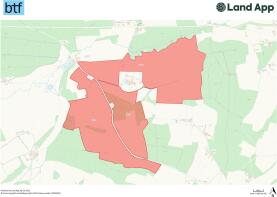
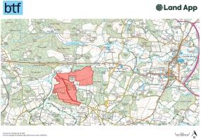
Wickhurst Farm is situated on the border of Kent and East Sussex and has been in the same ownership for several years. The Farm is available for sale by private treaty as a whole or in three separate lots. This farm provides a purchaser with an excellent opportunity to acquire a working arable unit with buildings in excess of 200 acres with good sized parcels and versatile soil types in a sought after area of West Kent/East Sussex. The land is currently farmed under a Contract Farming Agreement with arable crops. The land has potential for Biodiversity Net Gain and has sporting rights with a shoot and river frontage and amenity within the high value residential locality. Please see the location plan below identifying the ownerships being offered for sale outlined in red.
LOT 1 - WICKHURST FARM NORTH - 110.05 ACRES
Wickhurst Farm North comprises various parcels of arable and grass land extending to 110.05 acres. The arable land extends to 101.61 acres with a single parcel of permanent grass central to the parcel that extends to 8.44 acres. There is river frontage to the north and the fields are of a good working size.
LOT 2 - WICKHURST FARM SOUTH - 49.38 ACRES
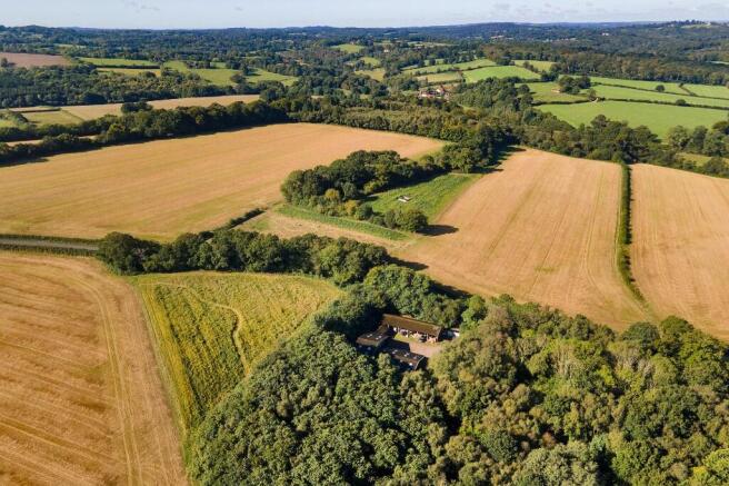
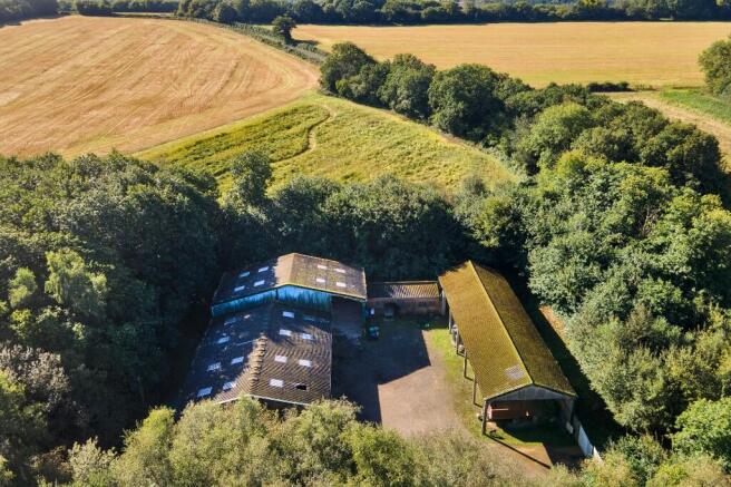
Wickhurst Farm South comprises two arable parcels divided by a central belt of woodland along with a range of agricultural buildings. This lot extends to 49.38 acres with 33.81 acres in an arable cropping rotation, 15.25 acres of woodland and 0.32 acres for the yard and buildings.
The range of buildings comprise steel & concrete portal frame structures under pitched corrugated fibre cement roofs with hard core and concrete yard areas. The buildings have the benefit of mains electricity and water. There will be an overage provision in place in favour of the vendor for 25% of any uplift in value for any residential consent over ten years after completion of the sale. The exact area included within the overage is available from the selling agents on request.
LOT 3 - WICKHURST FARM WEST - 87.35 ACRES
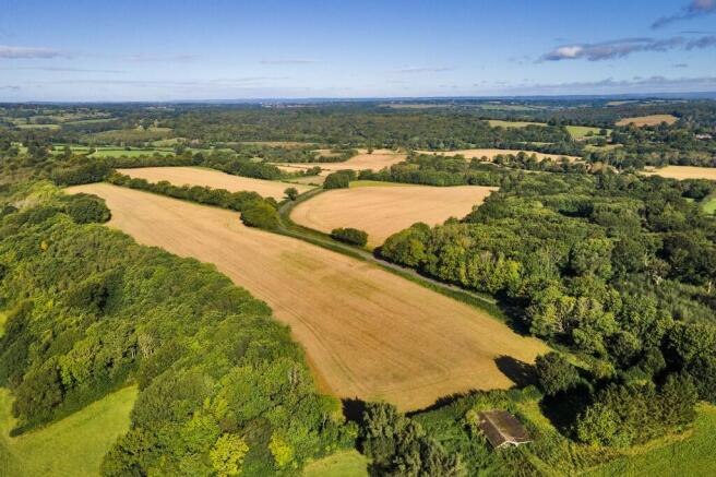
Wickhurst Farm west is all the land to the west of Bartley Mill Road and extends to 87.35 acres. The land is predominantly arable 81.78 acres along with a small area of woodland 5.57 acres. Certain areas are used by the local shoot for cover crops but the land is gently undulating down to the north.
The land in its entirety is classified as Grade III on the Agricultural Land Classification Plan for England & Wales. Soil types are relatively free draining, typical of this part of the High Weald locality. The woodland at Wickhurst is made up of natural broadleaved species and used by a shoot under the terms of a verbal arrangement. There is potential for the farm in Biodiversity Net Gain as well as nitrate neutrality along the river frontage.
Please see the boundary plan showing the extent of the land and buildings included within their own lots.
Brochures
Sales ParticularsWickhurst Farm, Lamberhurst, East Sussex Border

NEAREST STATIONS
Distances are straight line measurements from the centre of the postcode- Wadhurst Station1.6 miles
- Frant Station2.0 miles
- Tunbridge Wells Station4.1 miles
Notes
Disclaimer - Property reference Lot1Wickhurst. The information displayed about this property comprises a property advertisement. Rightmove.co.uk makes no warranty as to the accuracy or completeness of the advertisement or any linked or associated information, and Rightmove has no control over the content. This property advertisement does not constitute property particulars. The information is provided and maintained by BTF Partnership, Heathfield. Please contact the selling agent or developer directly to obtain any information which may be available under the terms of The Energy Performance of Buildings (Certificates and Inspections) (England and Wales) Regulations 2007 or the Home Report if in relation to a residential property in Scotland.
Map data ©OpenStreetMap contributors.