Pixham, Pixham End, Dorking

- SIZE
Ask agent
- SECTOR
Land for sale
Key features
- Consented residential conversion and new build development opportunity
- The site is situated on the outskirts of Dorking. Adjacent to Dorking Station
- 259 flats with a total NSA of 173,180 sq ft
- 41 new build townhouses with a total NSA of 66,454 sq ft
- Planning pending for 69 townhouses with a total NSA of 92,936 sq ft
- 3 detached commercial buildings with a total GIA of 19,347 sq ft
- Potential to repurpose/replan the commercial area for further development
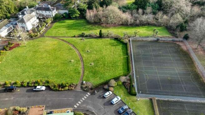
- 15.12 acres of amenity land
- Freehold interest for sale with vacant possession
- Offers are invited on an unconditional and subject to planning basis
Description
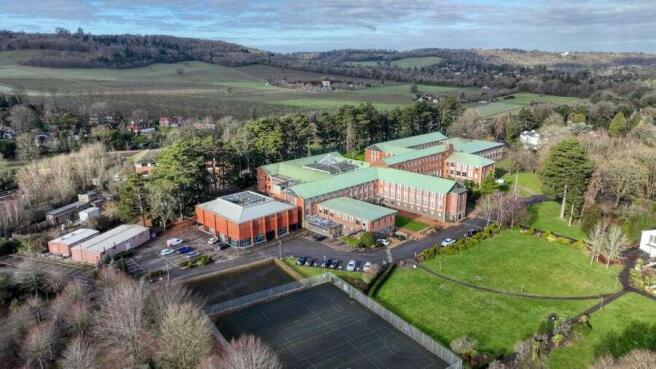
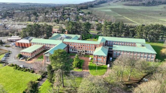
The site comprises a substantial former office building that was formerly the offices of Aviva. It was built in 1957. The existing building comprises a rectilinear group of office buildings, with a central spine block, orientated north- south, with a series of open and enclosed courtyards, and three projecting wings on the eastern portion of the site, which are orientated east-west. The southernmost enclosed courtyard has an atrium roof. The overall length of the building is approximately 175m. The office building has been subject to some strip out works internally.
To the north east of the offices is an area known as the former Friends Provident Sports and Social Club, which included some residential accommodation formerly occupied by club staff. The building group comprises the original early 20th century building, and numerous later extensions and accretions to the east and west, including a large sports hall.
In the south eastern part of the site is car parking for approximately 200+ vehicles.
To the north is an area of permanent pasture and a listed walled garden totalling approximately 15.12 acres.
Lot 1: Aviva Building - Planning permission for conversion and a two storey extension to deliver 259 apartments
2A: Former Friends Provident Building - Detailed planning for 41 Townhouses
2B: Planning pending for 69 Townhouses
Community Led Buildings - Detailed planning for 3 commercial buildings (Use Class E)
15.12 acres of Amenity/BNG Land
Pixham End is located in Dorking, Surrey. Dorking is an affluent market town in Surrey in the South East England about 21 miles (34km) south of London and 10 miles (16km) to the east of Guildford. Dorking itself lies in the scenic Surrey Hills, an area of outstanding natural beauty. The surrounding region offers access to numerous walks and outdoor activities, especially in the nearby Box Hill, which is a popular destination for hiking and enjoying panoramic views of the countryside.
The site is situated approximately 0.8 miles (1.3km) to the north east of Dorking town centre. Dorking town offers a good range of shops and services, notably a Waitrose & Partners and a Sainsbury’s. The site is situated opposite Denbies Wine Estate to the west at the foot of Box Hill.
There are a number of well regarded schools in the area including St. Martin’s CofE Primary School, The Ashcombe School and Box Hill School.
Brochures
Pixham, Pixham End, Dorking

NEAREST STATIONS
Distances are straight line measurements from the centre of the postcode- Dorking Station0.2 miles
- Dorking (Deepdene) Station0.3 miles
- Boxhill & Westhumble Station0.8 miles
Notes
Disclaimer - Property reference 183331AF-5DBD-45D5-B0C8-EC5349067838. The information displayed about this property comprises a property advertisement. Rightmove.co.uk makes no warranty as to the accuracy or completeness of the advertisement or any linked or associated information, and Rightmove has no control over the content. This property advertisement does not constitute property particulars. The information is provided and maintained by Savills, Guildford. Please contact the selling agent or developer directly to obtain any information which may be available under the terms of The Energy Performance of Buildings (Certificates and Inspections) (England and Wales) Regulations 2007 or the Home Report if in relation to a residential property in Scotland.
Map data ©OpenStreetMap contributors.