Land & Building at Little Panson, Launceston
- PROPERTY TYPE
Land
- SIZE
Ask agent
Key features
- 19.91 acres
- Newly erected agricultural barn
- New Fencing & Gates
- Well maintained hedgerows
- Newly installed mains water system & troughs
- Mains electric supply
Description
Description:
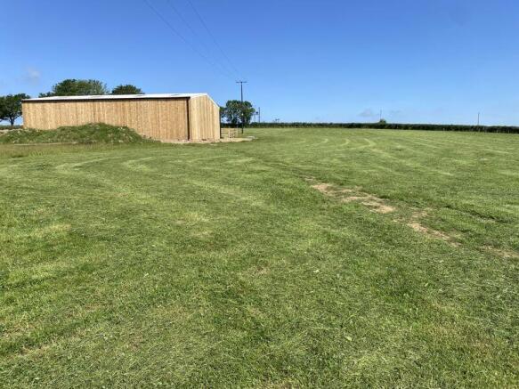
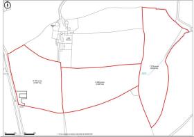
The property extends to around 19.91 acres (8.06ha) of level to gently sloping land, split into three conveniently sized parcels. Access is directly off the A388 into field no 9609 where the newly erected agricultural barn is located with planning permission 1/0570/2024/FUL consisting of a galvanized steel portal framed building measuring 11.96m x 18.46m, with crushed stone floor and timber clad sides all under a corrugated cement fibre roof with light sheets. The external yard area is fully fenced and railed with hardened stone, with a further gateway into the fields to the east.
Situation:
The land is situated to the north of St Giles on the Heath, an idyllic Devonshire village with good access into the local town of Launceston just over the Cornish border. The land is 6 miles north of Launceston, 8 miles south of Holsworthy and 21 miles east of Oakhampton with good access on the A30.
Description:
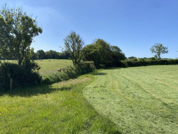
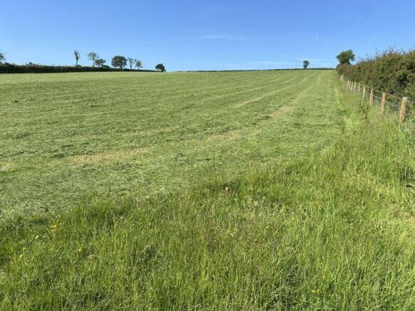
The property is an agricultural holding consisting of grass leys & lower grazing meadows extending to around 19.91 acres (8.06ha) including a modern agricultural building. The land is split into three conveniently sized plots with well maintained hedgerows, new fencing and gates, newly installed mains water system with troughs throughout and mains electric. Further development potential and suitable for the grazing of livestock, horses and ponies or for amenity use subject to the necessary permissions
Access:
Access directly off the public highway to the west known as the A388.
Local Authority:
Torridge District Council, Riverbank House, Bideford, EX39 2QG.
Services:
Water Supply: There is a metered mains water supply throughout the property servicing each field with a water trough.
Electricity: There is a new mains electrical supply connection to the property.
Boundaries, Roads & Fencing:
The Purchaser/Purchasers shall be deemed to have full knowledge of the boundaries, and neither the Vendor, nor their Agent will be responsible for defining the ownership of the boundary fencing and hedges. Where it is known boundary ownership shall be marked by a 'T' on the sales plan.
Wayleaves, Rights & Easements:
The property is sold subject to any wayleaves, public or private rights of ways, easements and covenants and all outgoings, whether mentioned in the sales particulars or not. The property is not subject to any public footpaths or rights of way.
Planning & Development:
The property is free from any restrictions for building however, there is an overage providing for the payment of 30% of the uplift in value as a result of the granting of any residential planning permission being for one unit or more, until February 2044
Environmental Stewardship:
The property is subject to a Mid-Tier agreement – that if accepted it will transferred upon completion.
Tenure:
The property is available freehold with vacant possession. Land Registry Title DN767145
Viewing:
Viewing is available during daylight hours subject to prior registration with Rendells - Newton Abbot
Tel no. . Buyers will need to have a copy of the particulars to hand.
Health & Safety:
Applicants/purchasers enter and view the property entirely at their own risk and no responsibility is accepted by the vendors or the agents.
Plan:
The sale plan is for identification purposes only, all would be purchasers are advised to make a thorough inspection of the property to be aware of its full extent.
Directions:
Leave the A30 at the Tavistock/A384 junction, turn onto the A388 and follow this road through the village of St Giles on the Heath until the property appears on the right.
What3Words:
///script.contrived.neon
Brochures
Property BrochureFull DetailsLand & Building at Little Panson, Launceston

NEAREST STATIONS
Distances are straight line measurements from the centre of the postcode- Gunnislake Station14.0 miles
Notes
Disclaimer - Property reference 12689003. The information displayed about this property comprises a property advertisement. Rightmove.co.uk makes no warranty as to the accuracy or completeness of the advertisement or any linked or associated information, and Rightmove has no control over the content. This property advertisement does not constitute property particulars. The information is provided and maintained by Rendells, Newton Abbot. Please contact the selling agent or developer directly to obtain any information which may be available under the terms of The Energy Performance of Buildings (Certificates and Inspections) (England and Wales) Regulations 2007 or the Home Report if in relation to a residential property in Scotland.
Map data ©OpenStreetMap contributors.