
Lag Lane, Thorpe Arnold, Melton Mowbray, Leicestershire, LE14

- PROPERTY TYPE
Land
- SIZE
57,064 sq ft
5,301 sq m
Key features
- Highly sought after village location
- Exciting new development opportunity
- Planning for Four Executive homes
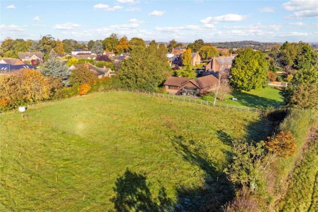
- Site plot about 1.31 acres
- Ideal for a self builder or developer
Description
Description
Positioned on the fringe of the highly popular Leicestershire village of Thorpe Arnold, this 1.3 acre building plot benefits full planning permission for four detached properties.
The proposals have been designed to complement and enhance their setting. Each new dwelling sits in a well
proportioned plot that assimilates well with the existing village development.
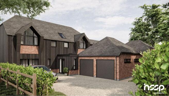
The mix of building types have been developed to break up the overall form of the site, removing any likening to a “standard” housing development. Finished in dark timber cladding with brickwork plinth details and larger areas of brickwork in places. The proposals limit the amount of brickwork that might be seen from the wider site context to help the new dwellings merge with the rural colours and textures.
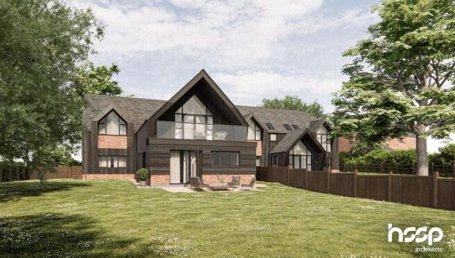
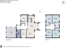
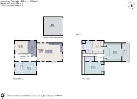
Plot One, a detached family home offering approximately 2734 ft.² of accommodation. In brief the accommodation will comprise: Reception hall, downstairs cloaks, a generous open plan living dining kitchen spanning the whole width of the property. Study/ snug and a utility room complete the ground floor accommodation. To the first floor, four bedrooms all with en suite facilities. A generous double garage and gardens to the rear.
Plot Two, a detached family home offering approximately 2350 ft.² of accommodation. In a brief the accommodation will comprise: Reception hall, open plan living dining kitchen, study/snug, utility room, downstairs cloaks and bedroom three with en suite facilities.
To the first floor - Bedroom one with dressing room, en suite bathroom and balcony. Bedroom two with en suite shower room. Generous double garage with gardeners to the rear
Plot Three, a detached family home offering approximately 2432 ft.² of accommodation. In brief will comprise: Reception hall, open plan living / dining kitchen, snug/study, downstairs cloaks, utility room and bedroom three with en suite facilities.
First floor - Bedroom one with dressing room, balcony and en suite bathroom. Bedroom two with en suite facilities. Generous double garage with gardens to the rear.
Plot Four comprising the same size and layout as plot three.
PLANNING CONSENT
Planning permission was granted by Melton Borough Council in September 2022 for one replacement dwelling (demolition of existing dwelling), three new dwellings, new access road, public vehicle passing place, turning head and associated highways works under planning reference number 22/01014/FUL
The site enjoys the benefit of an existing property which has full amenities, gas water electric and foul water access to the village system. The adjacent paddock could be part of the development offer if required. Full planning permission was gained in the early summer of 2024 and since then the Melton Borough Council pre commencement conditions have all been met and approved and the section S278 approval has been granted approval from Leicestershire County Council Highways department for the turning head.
The development is at the very end of the village with three of the properties benefitting from a private driveway that could be a gated development.
Location
Thorpe Arnold is a small village located to the northeast of Melton Mowbray. The picturesque Lag Lane has a wonderful range of individual properties benefiting from the delightful position along this quiet leafy lane which extends out into the countryside, making this an ideal position for those who enjoy the outdoors. The parish church of St Mary the Virgin is located in the centre of the village and is constructed of local Ironstone and set in beautiful grounds.
The village is a short driving distance away from Melton Mowbray at the northern end, which has a large superstore. The town centre is bustling and has a number of amenities whilst Thorpe Arnold itself sits on the A607 onwards to Waltham on the Wolds and Grantham.
Historically the village is recorded in the Doomsday Book, among numerous English manors held by Hugh de Grandmesnil, sheriff of the county of Leicester, richly rewarded by William the Conqueror for his part in the Battle of Hastings 1066. Latterly the Duke of Rutland, who bought much of Thorpe Arnold in 1715, owned both villages.
Melton Mowbray Golf Club, one mile from the development, is set in rolling countryside with outstanding views across the Leicestershire Wolds, they welcome golfers of all ages and abilities to join us on our verdant parkland course. Thorpe Arnold Cricket Club is half a mile the development and is a very active club being represented in a number of leagues and divisions.
St Mary the Virgin is a modest but attractive church situated in the heart of the Village and a date of about 1300 for the original construction is suggested. The font has early stylised carvings of St Michael which may be late Saxon or very early Norman.
Acreage: 1.31 Acres
Additional Info
Melton Borough Council
Not banded as yet
Brochures
Web DetailsParticularsLag Lane, Thorpe Arnold, Melton Mowbray, Leicestershire, LE14

NEAREST STATIONS
Distances are straight line measurements from the centre of the postcode- Melton Mowbray Station1.4 miles

Notes
Disclaimer - Property reference NTS240196. The information displayed about this property comprises a property advertisement. Rightmove.co.uk makes no warranty as to the accuracy or completeness of the advertisement or any linked or associated information, and Rightmove has no control over the content. This property advertisement does not constitute property particulars. The information is provided and maintained by Savills, Nottingham. Please contact the selling agent or developer directly to obtain any information which may be available under the terms of The Energy Performance of Buildings (Certificates and Inspections) (England and Wales) Regulations 2007 or the Home Report if in relation to a residential property in Scotland.
Map data ©OpenStreetMap contributors.