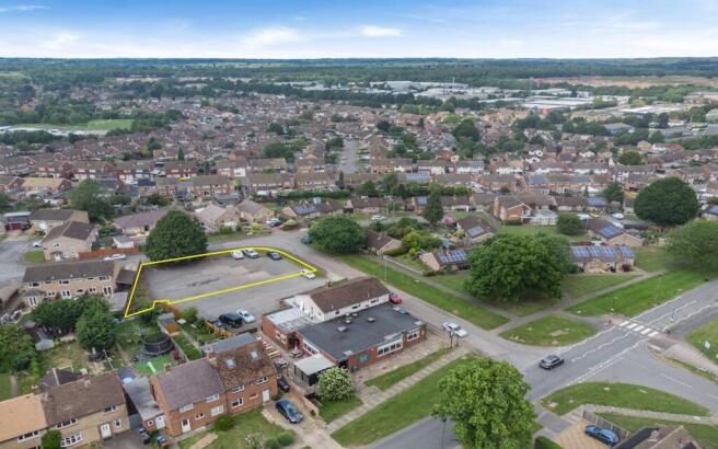
Land to rear of The Longboat, 61 Eastfield Road, Northampton, NN5 6TG

- SIZE AVAILABLE
9,148 sq ft
850 sq m
- SECTOR
Land for sale
Key features
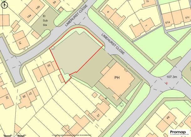
- Site area of 0.21 acres (0.085 ha)
- Excess car park surplus to pub requirements
- Potential for 4 dwellings at the rear (STP)
- Freehold unconditional and conditional offers invited
Description
The property occupies a site of approximately 0.21 acres (0.085 hectares), with the pub building positioned toward the south-east corner. Car parking is located to the north-west of the site and is accessed via Limehurst Close. The development land proposed is at the very northern end of the site, where there are some excess car parking spaces, not required by the pub to operate successfully.
Location
The property comprises land situated to the rear of The Longboat, a well-established public house located on Eastfield Road in Northampton. The surrounding area is predominantly residential, with a mix of housing and local amenities nearby, making it a well-populated and accessible part of the town.
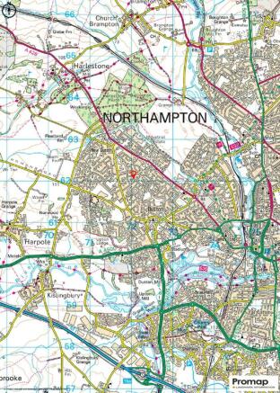
Northampton is a major regional centre in the East Midlands, located approximately 67 miles (108 km) north of London and 50 miles (80 km) southeast of Birmingham. The property benefits from good transport links, with the nearby A45 and A4500 providing access to the M1 motorway (Junctions 15 and 16), connecting Northampton to the wider national road network. Northampton town centre and mainline railway station are also within easy reach, offering regular services to London Euston and Birmingham New Street.
Tenure
Freehold subject to vacant possession.
Planning
The site is within the settlement boundary, not within a prohibitive flood zone, nor is the pub listed and it is not within a conservation area. In light of the above we believe that planning prospects are good, however all parties should satisfy themselves (STP).
On the two plans overleaf our client has had indicative schemes drawn up for the following:-
Option 1 - 4 x 2-bedroom houses, each measuring 852 sq ft (79.18 sqm), all with access from the same road.
Option 2 - 4 x 2-bedroom houses, each also measuring 852 sq ft (79.18 sqm), with Plots 1 and 2 accessed from one road, and Plots 3 and 4 accessed from a separate road.
Local Authority
North Northamptonshire Council.
Services
All parties to make their own enquiries to the serviceability to the land.
Guide Price
Offers are invited on an unconditional and conditional basis (STP).
VAT
VAT may be applicable at the prevailing rate.
Viewing
Where appropriate, we recommend interested parties carry out a discreet inspection of the site. We kindly request that no approaches are made to the publican, staff or the business directly, where applicable.
AML
Regulations require Savills to conduct various checks on purchasers and tenants. Further details are available upon request.
Brochures
Land to rear of The Longboat, 61 Eastfield Road, Northampton, NN5 6TG

NEAREST STATIONS
Distances are straight line measurements from the centre of the postcode- Northampton Station1.9 miles
About Savills, Southampton - Licensed Leisure
Savills, Mountbatten House,1 Grosvenor Square Southampton SO15 2BZNotes
Disclaimer - Property reference 303345-1. The information displayed about this property comprises a property advertisement. Rightmove.co.uk makes no warranty as to the accuracy or completeness of the advertisement or any linked or associated information, and Rightmove has no control over the content. This property advertisement does not constitute property particulars. The information is provided and maintained by Savills, Southampton - Licensed Leisure. Please contact the selling agent or developer directly to obtain any information which may be available under the terms of The Energy Performance of Buildings (Certificates and Inspections) (England and Wales) Regulations 2007 or the Home Report if in relation to a residential property in Scotland.
Map data ©OpenStreetMap contributors.