Low Burradon Farm, Thropton
- PROPERTY TYPE
Farm
- SIZE
12,486,124 sq ft
1,160,000 sq m
Key features
- AGRICULTURAL INVESTMENT OPPORTUNITY
- Let on a Agricultural Holdings Act 1986 tenancy agreement
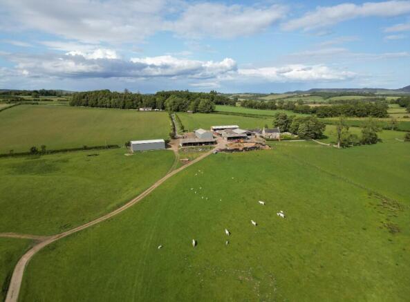
- 116 Hectares (286 Acres) Northumbrian mixed farm
- Situated in the scenic Coquetdale Valley
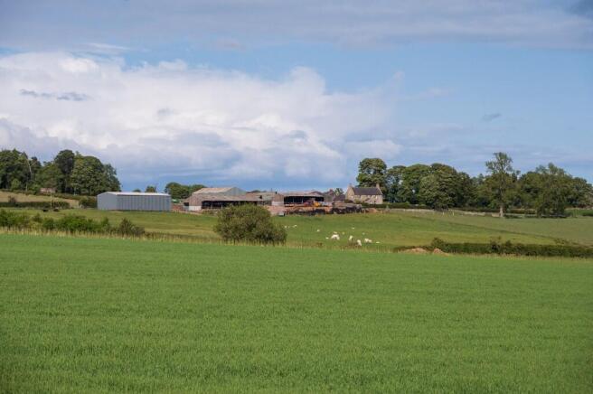
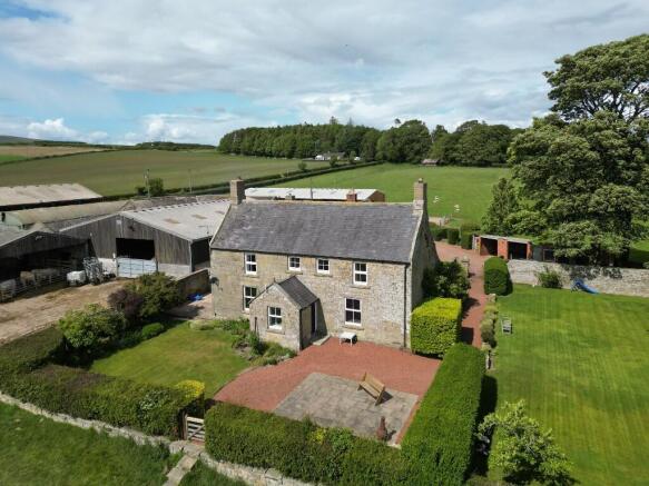
- Comprising a farmhouse, farm workers' cottage and a range of modern and traditional buildings
- Arable and grass rotation alongside permanent pastures
- Offered for sale as a whole and subject to tenancy
Description
116 Hectares (286 Acres) Northumbrian mixed farm situated in the scenic Coquetdale Valley and let on a Agricultural Holdings Act 1986 tenancy agreement.
Principal farmhouse and farm workers cottage
Range of modern and traditional farm buildings
Approximately 24 hectares (59 acres) of arable cropping, 48 hectares (119 acres) of temporary grass and 40 hectares (100 acres) of permanent pasture and rough grazing plus small area woodland
FOR SALE AS A WHOLE AND SUBJECT TO TENANCY
SITUATION
Low Burradon Farm is situated in the Lower Coquetdale Valley overlooking the Simonside Hills, approximately 6 miles northwest of the small town of Rothbury and 22 miles north of the larger market town of Morpeth. Situated in the lee of the Cheviot Hills, Low Burradon is on the edge of the Northumberland National Park. Combined with the area's obvious natural beauty is the well regarded productivity and output of the farmland in this famed livestock area.
DESCRIPTION
Low Burradon Farm is held in a ring fence and varies in height from 200 meters above sea level on the northern boundary down to 132 meters at the Foxton Burn that runs through the holding.
The farm benefits from a principal farmhouse plus a small "Bothy" cottage. Temporary grass leys, permanent grassland and rotational arable cropping coupled with a range of modern and traditional buildings provide an exciting proposition for interested potential investors.
HISTORY
The farm has belonged to the same family since the 1950s however it has been let to and farmed by the tenant's family since 1931. The current tenant should be complemented for the manner in which he farms and maintains the holding. He has made significant investments to improve and expand the steading in recent years with many of the farm buildings belonging to him. The farming family run a noted herd of pure Charolais cattle at Low Burradon alongside a flock of breeding ewes and a small arable rotation.
Brochures
Sales BrochureEnergy Performance Certificates
Property EPCsLow Burradon Farm, Thropton

NEAREST STATIONS
Distances are straight line measurements from the centre of the postcode- Acklington Station15.3 miles
About Richard Brown & Partners, Belford
The Office, South Bellshill, Bellshill, Belford, NE70 7HP
Notes
Disclaimer - Property reference LowBurradonThropton. The information displayed about this property comprises a property advertisement. Rightmove.co.uk makes no warranty as to the accuracy or completeness of the advertisement or any linked or associated information, and Rightmove has no control over the content. This property advertisement does not constitute property particulars. The information is provided and maintained by Richard Brown & Partners, Belford. Please contact the selling agent or developer directly to obtain any information which may be available under the terms of The Energy Performance of Buildings (Certificates and Inspections) (England and Wales) Regulations 2007 or the Home Report if in relation to a residential property in Scotland.
Map data ©OpenStreetMap contributors.