Toot Lane, Boston
£4.10 per sq ft
Business rates & charges may apply

- SIZE AVAILABLE
1,187,882 sq ft
110,358 sq m
- SECTOR
Plot for sale
Key features
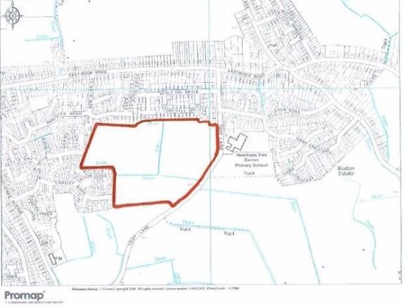
- Approx 9.50 Acres
- Planning Expired 2019
- Greenfield Site with Extensive road frontage.
Description
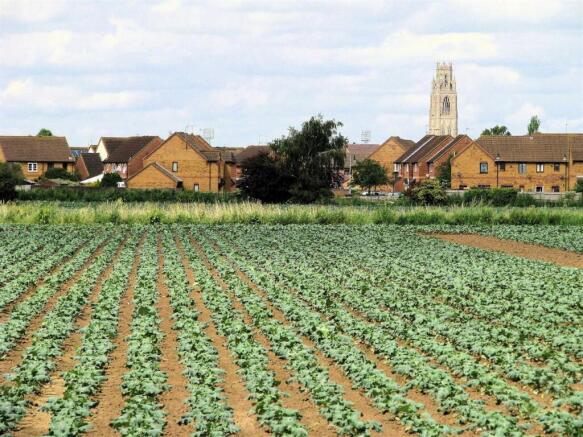
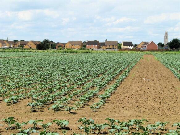
The site has residential neighbourhoods to the northern, eastern and western boundaries with the successful Hawthorn Tree Primary School and Hawthorn Tree Community Children's Centre directly opposite. The Council Planners have confirmed they will also consider a Care Home to part of the site.
Location - The site is situated immediately off Toot Lane, a popular residential area , approximately 1.6 miles from Boston Town Centre. The site is encircled by residential development having Taylor Close, Reams Close, Meridian Road, Churchill Drive and Hawthorn Close surrounding three of the boundaries.
Residents of the area currently benefit from two Post Offices with shops, a Lincolnshire Co-Operative Store, two petrol stations, Play Towers children's activity centre, Boston Ten-pin Bowling Centre and Rochford Tower Tennis Club. There is also a bus stop directly in front of Hawthorn Tree school.
Toot Lane has recently had a new cycleway and pedestrian area constructed to provide easy access to the Children's Centre and School together with the growing residential area.
Boston Grammar School and Boston College are situated nearby whilst Boston's prime commercial centres and the Port of Boston are in close proximity.
Description - The subject site is approx. 27.47 Acres, 11.12 Hectares (STS) with direct road frontage, approx. 1185 ft, onto Toot Lane and easy access to Boston Town Centre.
The site can be accessed directly from Eastwood Road to the north or via the roundabout to the south of Toot Lane which connects Woodthorpe Avenue, Kingsway and White House Lane to Toot Lane.
A Ground Investigation Report from February 2021 is owned by the Landowners and is available for interested parties.
Planning - The site received Outline Planning Permission from Boston Borough Council B/14/0103 for the development of 340+ dwellings in three phases. This application expired in 2019.
More recently, the Council Planners expressed an interest in a hybrid development comprising of 320 dwellings with a further Care Home, application B/22/0428.
The land represents a main development site within the Local Plan for Boston. The site is referred to as a Housing Commitment under Policy 11 of the Local Plan.
The site will require a new planning application for development. The Case Officer within the Planning Department dealing with the site is Lewis Humphreys Tel: email: lewis.
Tenure - The site is offered for sale as a freehold site.
Services - The owners inform us mains gas, electricity and water are available. Prospective buyers should make their own enquiries in this regard.
Directions - From our offices in Pump square proceed via Main Ridge West which leads into Pen Street. At the traffic lights turn right into Botolph street, turn right onto John Adams Way (inner relief road) and then immediately left onto Main Ridge East. Continue over Vauxhall Bridge (over the Maud Foster Watercourse). The road becomes Freiston Road and in turn Eastwood Road. After passing the General Store on the corner of Lindis Road( left hand side ) take the fifth turning right into Toot Lane. Continue and the site is situated on the right hand side, opposite the school.
Energy Performance Certificates
EE RatingEI RatingBrochures
Toot Lane, Boston

NEAREST STATIONS
Distances are straight line measurements from the centre of the postcode- Boston Station1.7 miles
- Hubberts Bridge Station5.0 miles
Notes
Disclaimer - Property reference 33985491. The information displayed about this property comprises a property advertisement. Rightmove.co.uk makes no warranty as to the accuracy or completeness of the advertisement or any linked or associated information, and Rightmove has no control over the content. This property advertisement does not constitute property particulars. The information is provided and maintained by Bruce Mather Limited, Boston. Please contact the selling agent or developer directly to obtain any information which may be available under the terms of The Energy Performance of Buildings (Certificates and Inspections) (England and Wales) Regulations 2007 or the Home Report if in relation to a residential property in Scotland.
Map data ©OpenStreetMap contributors.