Mill Lane SO32 3QH

- PROPERTY TYPE
Land
- SIZE
517,493 sq ft
48,077 sq m
Key features
- SEE AND PRINT PDF SALES PARTICULARS AVAILABLE BELOW
- SEE DRONE VIDEO FOOTAGE ON THE VIRTUAL TOUR TAB
- EXTENDS TO APPROX. 11.88 ACRES
- PLANNING CONSENT FOR 6 STABLES, TACK ROOM, HAY STORE AND WASHDOWN AREA
- CARAVAN FOR WELFARE USE
- PASTURE LAND APPROX. 11. 45 ACRES
- CLOSE TO THE A32
- ROAD FRONTAGE
- ADJACENT TO THE MEON VALLEY TRAIL
- WITHIN THE SOUTH DOWNS NATIONAL PARK
Description
VIDEO DRONE FOOTAGE: See the Selling Agent's website for further details, photographs and drone video footage is available showing the whole property.
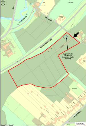
LOCATION: See Location Plans. Postcode: SO32 3QH. The Property is located off Mill Lane, Soberton. What3words of Vehicular Access:
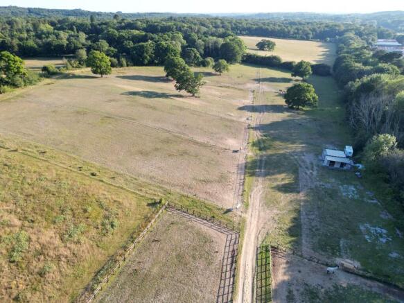
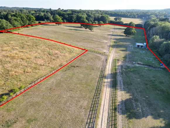
DESCRIPTION: The Property extends to approx. 11.88 acres (4.81 ha) including approx. 11.45 acres of permanent pasture land divided into 10 paddocks by post and rail fencing, approx. 0.24 acres of woodland and approx. 0.19 acres of trackway. The boundaries comprise mainly of post and rail fencing in front of mature hedgerows and trees. There are also several mature trees scattered across the eastern part of the pasture land.
The land is currently in use for equestrian grazing. It benefits from road frontage along its eastern boundary with Mill Lane with access via a hardstanding track from the gate on Mill Lane (see arrow on the Site Plan). The Meon Valley Trail runs immediately adjacent to the northern boundary.
According to the Agricultural Land Classification Survey the land is Grade 4. The Geological Survey Map indicates that the Property is within an area of slowly permeable seasonally wet slightly acid but base-rich loamy and clayey soils. The land has a northerly aspect and slopes into the valley towards the River Meon ranging from around 70m above sea level to around 55m above sea level.
CONSENT FOR STABLES: By Planning Consent SDNP/24/02731/FUL dated 11th June 2025, permission has been granted for the erection of timber barn (approx. 18m by 13m) containing 6 stables (4 x14ft by 12ft and 2 x 21ft by 12ft), a tack room, hay store and washdown area. The use of the land has also been changed from agricultural to equestrian use.
Conditions on the Decision Notice include the limitation of the use of the building to the keeping of horses for private recreational use; limitation on the number of horses occupying the stables to 8; restrictions on vehicles parked on-site (1 small caravan for welfare; 1 horsebox; 1 manure trailer and 3 cars); restrictions on the erection of horse jumps, outside storage and the subdivision of fields and requirements relating to external lighting, manure and waste management, ecology, biodiversity net gain, tree/hedgerow planting and construction of the access track/parking area. See Decision Notice available on the Selling Agents website.
The approximate location of the proposed building is indicated by the blue dashed outline on the Site Plan. The Floorplan/Elevations for the proposed building are included below. Full details of the application can be obtained via the South Downs Local Planning Authority Website -SDNP/24/02731/FUL.
FIELD SHELTERS: There are currently two timber field shelters on the land at the positions marked S on the Site Plan which will be included with the sale.
CARAVAN: There is currently a caravan positioned on the Property to the immediate west of the field shelters. This caravan has been used for welfare purposes. It is limited to this use by Condition 7 of Planning Consent SDNP/24/02731/FUL.
MEON VALLEY TRAIL: The picturesque Meon Valley Trail which passes immediately adjacent to the northern boundary provides an excellent hacking opportunity and can currently be accessed from Mill Lane. As the boundary is adjacent, there is potential to open an access directly from the Property through the hedgerow onto the Trail. The Trail, a disused railway line, provides an easy and safe route from Wickham approximately 2 miles south-west to West Meon approximately 7 miles north-east passing through other settlements on the way and connecting with other parts of the public rights of way network. It can be used for walking, cycling or horse riding.
LAND REGISTRY: The Property comprises part of Land Registry Title HP870676. Copy of Land Registry Title Plan and Register available on the Selling Agent's website.
PLANNING DESIGATIONS: The Property is within the South Downs National Park and the Local Plan shows the land to be 'Countryside'. There is a mineral safeguarding area protecting sharp sand and gravel resources affecting a part of the land on the southern boundary and another protecting clay resources on part of the land on the northern boundary - see link to Planning Policy Map - Planning Policy Map.
PLANNING APPLICATIONS: There are a number of recent planning applications relating to the Property including several unsuccessful attempts to obtain consent for stables and a menage prior to the successful application described above - SDNP/24/02731/FUL. For a full list of recent planning applications relating to the Property, please see the Selling Agent's website.
DESIGNATIONS: The property is situated within the South Downs National Park and the South Hampshire Lowlands National Character area. No other significant environmental designations have been identified.
OTHER RIGHTS: By Deed of Grant dated 12th July 2010, an easement was granted for the benefit of Portsmouth Water relating to three water pipes which pass under the Property. As is usual with an easement of this kind, there are restrictions within the easement width (from 5m and 10m on different parts of the Property) preventing the erection of buildings/structures, the planting of trees and any other operations likely to interfere with the water pipes in these areas. To understand the locations of these water pipe easements, please review the Deed of Grant and Easement Plan available on the Selling Agent's website.
There are overhead electricity wires present on the western part of the Property. The Vendors are not aware that any wayleave payments have been received relating to the electricity poles and wires during their ownership. Other rights are referred to on the Land Registry Title Register and we recommend that interested parties familiarise themselves with the Land Registry Title Register and Plan available on the Selling Agent's website.
PUBLIC RIGHTS OF WAY: No public rights of way cross the Property.
BUSINESS RATES: Not currently demanded or assessed.
SERVICES: No services are currently connected. Services are understood to be available in Heath Road. The current owner does carry out some rainwater harvesting off the field shelter roofs.
LOCAL AUTHORITY: Winchester City Council, City Offices, Colebrook Street, Winchester SO23 9LJ.
PLANNING AUTHORITY: South Downs National Park (SDNP), South Downs Centre, North Street, Midhurst, West Sussex, GU29 9DH.
Brochures
Sales ParticularsMill Lane SO32 3QH

NEAREST STATIONS
Distances are straight line measurements from the centre of the postcode- Botley Station4.9 miles
About Giles Wheeler-Bennett, Southampton
West Court, Lower Basingwell Street, Bishop's Waltham, SO32 1AJ
Notes
Disclaimer - Property reference MillLaneSoberton. The information displayed about this property comprises a property advertisement. Rightmove.co.uk makes no warranty as to the accuracy or completeness of the advertisement or any linked or associated information, and Rightmove has no control over the content. This property advertisement does not constitute property particulars. The information is provided and maintained by Giles Wheeler-Bennett, Southampton. Please contact the selling agent or developer directly to obtain any information which may be available under the terms of The Energy Performance of Buildings (Certificates and Inspections) (England and Wales) Regulations 2007 or the Home Report if in relation to a residential property in Scotland.
Map data ©OpenStreetMap contributors.