
Land to the rear of Willis Croft, Warton, Tamworth, B79 0EU

- PROPERTY TYPE
Land
- SIZE
2,473,772 sq ft
229,821 sq m
Key features
- Arable land
- 56.79 acres
- Grade 3 land
- Freehold
Description
Location - The land is located in the rural village of Warton, approximately 6 miles to the east of Tamworth and approximately 4 miles to the northwest of Atherstone.
The land is accessed via Willis Croft, off Austrey Road.
The A5 is approximately 4 miles to the south, providing convenient access to the M42 and further afield.
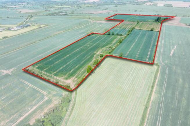
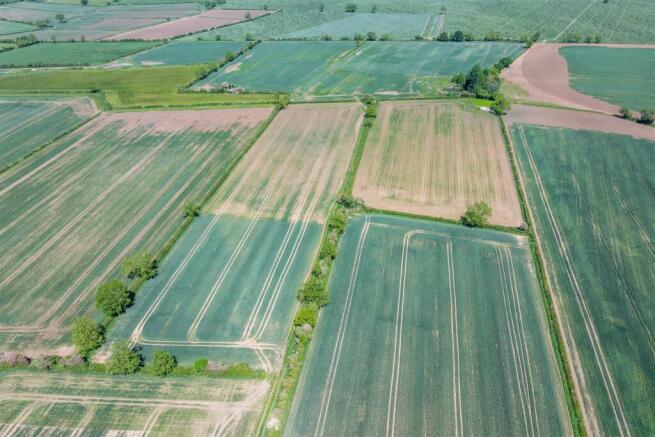
Description - The land extends to approximately 56.79 acres of arable land split into five parcels. The land is classified as Grade 3 on the Agricultural Land Classification Map and according to The Soil Map of England and Wales, the soil is a reddish fine loamy soil of the Hodnet series.
A small section of the land falls within Floodzone 3.
Overage Clause - The land will be sold with an overage clause will reserve 30% of any uplift in value attributed to any change of use or planning permission on the land for a period of 30 years.
For the avoidance of doubt, the overage clause will not be triggered by any agricultural, equestrian or forestry uses.
Services - We understand that the land does not benefit from any mains services. Purchasers are to make their own enquiries as to connectivity.
Holdover - The land is currently in crop and the tenant retains the right to harvest this crop in 2025.
Sporting And Mineral Rights - Where sporting and mineral rights are owned, they will be included in the sale.
Tenure - The land is being sold freehold. The land is currently let on a Farm Businss Tenancy which is due to end on 30th October 2025, at which point vacant possession will be available.
Easements, Wayleaves And Rights Of Way - The land is accessed via Willis Croft off Austrey Road, as shown by the blue dotted line on the sale plan.
The purchaser will be granted a right of way along the access track beyond Willis Croft, as shown by the green dotted line on the sale plan.
We understand that there is a gas pipeline which crosses through the land.
The land is sold subject to and with the benefit of any easements, wayleaves and rights of way that may exist at the time of sale, whether disclosed or not.
Method Of Sale - The land will be sold by private treaty.
Local Authority - North Warwickshire Borough Council
What3words - ///afraid.opposite.radically
Viewing - Viewings are strictly by appointment. Please contact Susannah Leedham at the Atherstone office.
Plan, Area And Description - The plan, area and description are believed to be correct in every way, but no claim will be entertained by the vendor or their agents in respect of any error, omissions or misdescriptions.
The plan is for identification purposes only.
Anti Money Laundering - Under the Money Laundering Directive (S1 2017/692) we are required under due diligence as set out under HMRC to take full identification (e.g. Photo ID and recent utility bill as proof of address) when a potential purchaser submits an offer for a property. Please be aware of this and have the information available.
Please note a fee of £30 will be charged for the Anti-Money Laundering check via our online system Move Butler.
Brochures
Land to the rear of Willis Croft Brochure.pdfBrochureLand to the rear of Willis Croft, Warton, Tamworth, B79 0EU

NEAREST STATIONS
Distances are straight line measurements from the centre of the postcode- Polesworth Station1.2 miles
- Atherstone Station3.8 miles
- Wilnecote Station4.3 miles


Notes
Disclaimer - Property reference 34024416. The information displayed about this property comprises a property advertisement. Rightmove.co.uk makes no warranty as to the accuracy or completeness of the advertisement or any linked or associated information, and Rightmove has no control over the content. This property advertisement does not constitute property particulars. The information is provided and maintained by Howkins & Harrison LLP, Atherstone. Please contact the selling agent or developer directly to obtain any information which may be available under the terms of The Energy Performance of Buildings (Certificates and Inspections) (England and Wales) Regulations 2007 or the Home Report if in relation to a residential property in Scotland.
Map data ©OpenStreetMap contributors.