
White House Farm, Low Lane, Friskney, Boston, Lincolnshire, PE22

- PROPERTY TYPE
Detached
- SIZE
Ask agent
- TENUREDescribes how you own a property. There are different types of tenure - freehold, leasehold, and commonhold.Read more about tenure in our glossary page.
Freehold
Key features
- Approximately 828.41 acres of highly productive Grade 1 soil
- 117.63 acres of foreshore offering potential natural capital based
- Grain and temperature controlled potato storage facilities
- Three residential properties and farm office
- Available as a whole or 2 lots
- EPC Rating = D
Description
Description
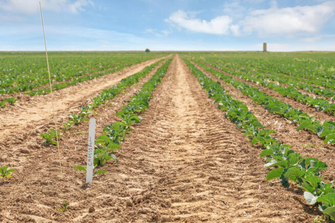
White House Farm is a highly productive, versatile arable farm in the north Lincolnshire Fens, an area known for its fertile oils, suitable for growing combinable crops and high value crops, with some of the land suitable for double cropping.
The cropped arable land, equating to 828.41 acres, is all classified as Grade 1 and served by a central track running the whole length of the farm. The fields are large and regular shaped, ideally suited to modern farming techniques. The land is farmed in hand and has been done so sympathetically, with the emphasis on soil management, whilst maximising productivity, particularly of the high value crops.
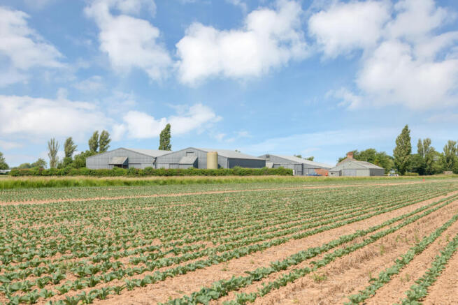
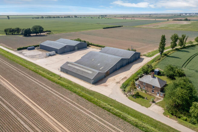
At the heart of the holding, the buildings at White House Farm serve as the operational base for the farm. A further farm building is located at the western end of the farm.
A wide-ranging cropping rotation is is in place across the farm, with cereals, vining peas, a variety of brassicas and potatoes grown successfully in recent years. The fields are large and regular in shape, enabling efficient farming operations. Public road access and internal tracks ensure excellent connectivity throughout the holding.
The soils are highly versatile and benefit from under drains which have been well maintained and updated when necessary, supporting consistent yields and year-round reliability. The land is in good heart and has been well maintained. The vendors have practiced a precision tillage farming system with the planting of brassicas through innovative strip drilling, improving the soil structure and livestock regularly graze the fields following the vegetables further enhancing the soil. The combination of these various techniques and approaches has led to a substantial improvement in yields and quality over the past ten years. Drainage plans and SOYL precision farming maps are available on request.
The soil is classified as belonging to the Wisbech series, typically described as deep stoneless calcareous coarse silty soils. The farm has a long track record of performance, with average yields of in excess of 10 tonnes for winter wheat, often drilled late following brassicas. The land has been cropped in a typical rotation for this land type, the wheat has been grown for seed with a range of different varieties produced across the farm. The potatoes are grown on licence, with a copy of the licence available in the data room.
The farm buildings are located at the western end of the farm and provide extensive storage facilities for 2,500 of combinable crop storage and 1,500 tonnes of temperature controlled potato storage.
Lot One: White House Farm
Farmland
Lot 1 comprises approximately 578.04 acres (233.93 hectares) of productive arable land, forming part of the wider commercial arable enterprise. The land is predominantly Grade 1, with a small area closest to the outer sea wall classified as Grade 4. The fields are large and regular-shaped, well-suited to modern farming techniques. It benefits from excellent access via public highways and a track running the length of the farm between lots 1 and 2.
The arable land runs down to the outer sea wall, with two further inner sea walls ensuring the farm is protected from the risk of flooding, should there ever be a tidal surge. The sea wall was breached in 2014, due to a tidal surge. Subsequently, extensive repairs and improvements took place and the bank was realigned. See page 13 for further details.
Soil from the farm was used to repair the breach and further strengthening the existing sea walls, which led to the creation of the lagoon at the western end of the farm. The area is now a haven for wildlife.
The foreshore extends to 117.96 acres (47.73 hectares), which was previously let on a lease to the Ministry of Defence (MOD). The MOD have a licence to access the foreshore, so as to deal with unexploded ordnance and maintain signage. Adjacent to the lagoon is a former RAF watchtower which may lend itself to alternative uses, subject to the necessary planning consents.
The main operational hub at White House Farm features a substantial range of buildings offering extensive storage facilities, including grain and temperature-controlled potato stores. The grain drying facilities are gas fired (LPG tanks), and the buildings are serviced by three-phase electricity.
A further building, situated at the northern end of lot 1, is used to store grain on a short-term basis (up to 500 tonnes) and fertiliser and has previously been the farm workshop. To the south of the farm building planning permission was granted for the erection of an agriculturally tied bungalow, part of the footings for the property where excavated.
Farm Office (1 Low Lane)
Formerly a 3 bedroom semi-detached cottage, the property was converted to accommodate the farm office and now includes kitchen, farm office, meeting rooms and welfare facilities.
2 Low Lane A brick semi-detached cottage under a slate roof, lying adjacent to the farm buildings at White House Farm. The property includes kitchen and living on the ground floor and two bedrooms and a family bathroom on the first floor. It is currently let on an Assured Tenancy to a former agricultural worker with the rent having been reviewed with effect from 1st July 2025.
Lot Two: Land at White House Farm
Farmland
Lot Two extends to around 250.37 acres of high-quality Grade 1 arable land, forming an integral part of the larger commercial farming operation. The soils are all Grade 1 and with some of the land being termed locally as Toft land delineating as some of the highest quality land. The land is accessed either from the A52 or the track running between lots 1 and 2.
Residential
1 Toft House - Situated at the end of a private drive off the A52, at the north-western end of Lot 2, 1 Toft House is a semi-detached brick cottage under a pantile roof, including kitchen, dining room and bathroom on the ground floor and three bedrooms on the first floor. The property is currently let on a periodic Assured Shorthold Tenancy Agreement.
2 Toft House - Forming the other half of the semi-detached cottage, 2 Toft House is a semi-detached brick cottage under a pantile roof, including kitchen, living room and bathroom on the ground floor and two bedrooms on the first floor. The property is currently let on a periodic Assured Shorthold Tenancy Agreement.
Acreage: 1044.16 Acres
Additional Info
Local Authority: East Lindsey District Council
2 Low Land: Council Tax Band A. EPC Rating E
1 Toft Cottages: Council Tax Band A. EPC Rating D
2 Toft Cottages: Council Tax Band A. EPC Rating D
Mains Water
Oil Fired Central Heating
Private Drainage
Photographs: June 2025 & Particulars July 2025
Brochures
Web Details- COUNCIL TAXA payment made to your local authority in order to pay for local services like schools, libraries, and refuse collection. The amount you pay depends on the value of the property.Read more about council Tax in our glossary page.
- Band: A
- PARKINGDetails of how and where vehicles can be parked, and any associated costs.Read more about parking in our glossary page.
- Yes
- GARDENA property has access to an outdoor space, which could be private or shared.
- Ask agent
- ACCESSIBILITYHow a property has been adapted to meet the needs of vulnerable or disabled individuals.Read more about accessibility in our glossary page.
- Ask agent
White House Farm, Low Lane, Friskney, Boston, Lincolnshire, PE22

Add an important place to see how long it'd take to get there from our property listings.
__mins driving to your place
Get an instant, personalised result:
- Show sellers you’re serious
- Secure viewings faster with agents
- No impact on your credit score
Your mortgage
Notes
Staying secure when looking for property
Ensure you're up to date with our latest advice on how to avoid fraud or scams when looking for property online.
Visit our security centre to find out moreDisclaimer - Property reference LIR250081. The information displayed about this property comprises a property advertisement. Rightmove.co.uk makes no warranty as to the accuracy or completeness of the advertisement or any linked or associated information, and Rightmove has no control over the content. This property advertisement does not constitute property particulars. The information is provided and maintained by Savills Rural Sales, Lincoln. Please contact the selling agent or developer directly to obtain any information which may be available under the terms of The Energy Performance of Buildings (Certificates and Inspections) (England and Wales) Regulations 2007 or the Home Report if in relation to a residential property in Scotland.
*This is the average speed from the provider with the fastest broadband package available at this postcode. The average speed displayed is based on the download speeds of at least 50% of customers at peak time (8pm to 10pm). Fibre/cable services at the postcode are subject to availability and may differ between properties within a postcode. Speeds can be affected by a range of technical and environmental factors. The speed at the property may be lower than that listed above. You can check the estimated speed and confirm availability to a property prior to purchasing on the broadband provider's website. Providers may increase charges. The information is provided and maintained by Decision Technologies Limited. **This is indicative only and based on a 2-person household with multiple devices and simultaneous usage. Broadband performance is affected by multiple factors including number of occupants and devices, simultaneous usage, router range etc. For more information speak to your broadband provider.
Map data ©OpenStreetMap contributors.